Storms rolled through Saskatchewan once again last night, just another day in what has become a very active storm season on the prairies.
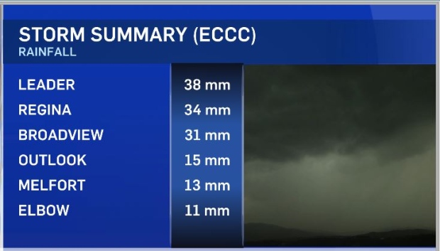
Drains in the city of Regina couldn’t keep up as 34 millimetres of rain feel in about 60 minutes. Underpasses were flooded and water overran people’s front yards and busy intersections. Other areas of the province saw similar numbers and there are reports of an estimated 98 mm in Nipawin over a 24-hour period. There are unconfirmed reports of a funnel cloud that may have touched down near white city.
So far this season Saskatchewan has had nine confirmed tornados, our average is 18. There are now three more possible tornados that haven’t been confirmed by Environment and Climate Change Canada. Alberta leads the way in 2019 with 12 tornadoes and Manitoba has only had one. That could change for the eastern Prairie province this afternoon with the most intense system expected in southern areas.
The storm outlook today puts Saskatchewan in the minor range for the most part, except for parts of southeast areas where moderate conditions set up. With a weak low pressure system near Watrous tracking east to northeast this afternoon and evening will see the development of scattered thunderstorms. With daytime heating and upper level cooling it is possible for some of these storms to become severe. Funnel clouds are always possible during days like this. Other threats include hail and wind gusts possible reaching 90 km/h.
For constant storm updates including any watches or warnings download the CTV Regina weather app.


