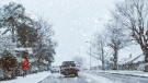
Severe thunderstorm watch lifted for Regina
A severe thunderstorm watch which was issued for the City of Regina on Friday morning has since been lifted.
According to Environment Canada, a weak cold front that was moving across the province from the west created favourable conditions for a storm capable of producing damaging wind gusts, large hail and heavy rain.
The severe storm watch comprised a region as far south as Regina, running east through Fort Qu’Appelle to Esterhazy, and as far north as Nipawin.
Saskatoon and several other communities in central Saskatchewan are still under a severe thunderstorm watch.
Some mid-northern communities like Waskesiu, in the Prince Albert National Park, were hit with a storm on Thursday evening that dropped golf-ball sized hail.
 A Waskesiu resident posted photos of hail found on the golf course on July 11, 2024. (Source: Tara Degelman / Facebook)
Environment Canada cautions Regina residents that these summer storms can pose a real risk to safety.
“Large hail can damage property and cause injury. Very strong wind gusts can damage buildings, down trees and blow large vehicles off the road,” Environment Canada says.
“Intense lightning is likely with any thunderstorm that develops. Remember, severe thunderstorms can produce tornadoes. Heavy downpours can cause flash floods and water pooling on roads.”
The forecast for Regina on Friday is a high of 28 C with a 30 per cent chance of showers and a low of 13 C overnight.
The risk of thunderstorms is expected to clear by midnight.
Shopping Trends
The Shopping Trends team is independent of the journalists at CTV News. We may earn a commission when you use our links to shop. Read about us.


CTVNews.ca Top Stories

Trump again calls to buy Greenland after eyeing Canada and the Panama Canal
First it was Canada, then the Panama Canal. Now, Donald Trump again wants Greenland.
King Charles ends royal warrants for Ben & Jerry's owner Unilever and Cadbury chocolatiers
King Charles III has ended royal warrants for Cadbury and Unilever, which owns brands including Marmite and Ben & Jerry’s, in a blow to the household names.
LIVE UPDATES
LIVE UPDATES Parts of Ontario under snowfall warning Monday as holiday travellers hit the road
Holiday travellers and commuters could be in for a messy drive on Monday morning as a significant round of snowfall moves into the region. Here are live updates on the situation in Toronto.
Statistics Canada reports real GDP grew 0.3 per cent in October
Statistics Canada says the economy grew 0.3 per cent in October, helped by strength in the mining, quarrying, and oil and gas extraction sector, following a 0.2 per cent increase in September.
U.S. House Ethics report finds evidence Matt Gaetz paid thousands for sex and drugs including paying a 17-year-old for sex in 2017
The U.S. House Ethics Committee found evidence that former Rep. Matt Gaetz paid tens of thousands of dollars to women for sex or drugs on at least 20 occasions, including paying a 17-year-old girl for sex in 2017, according to a final draft of the panel's report on the Florida Republican, obtained by CNN.
The rent-a-friend industry is booming among Canada's Chinese diaspora
Dozens of people are offering rent-a-friend services on Xiaohongshu, a social media platform also known as Little Red Book or China's Instagram, in cities including Vancouver, Calgary and Toronto.
Dozens of luxury condos and hotels in Florida are sinking, study finds
Dozens of luxury condos, hotels and other buildings in southeast Florida are sinking at a surprising rate, researchers reported in a recent study.
Nordstrom to be taken private by founding family for US$4B
Nordstrom will be acquired by its founding family and Mexican retailer Liverpool for nearly US$4 billion in an all-cash deal, going private at a time when high-end retailers are grappling with slow demand.
Biden gives life in prison to 37 of 40 federal death row inmates before Trump can resume executions
U.S. President Joe Biden announced on Monday that he is commuting the sentences of 37 of the 40 people on federal death row, converting their punishments to life imprisonment just weeks before president-elect Donald Trump, an outspoken proponent of expanding capital punishment, takes office.
Saskatoon
-

'There are lines': In year-end interview, NDP leader says Moe went too far in election campaign
Saskatchewan’s two main political leaders had agreed before October's provincial election not to target the families of candidates during the campaign, says Opposition NDP Leader Carla Beck.
-
Heavy fog hits Saskatoon, creating slippery roadways
Saskatoon is under a fog advisory on Monday, creating slippery conditions for commuters and last-minute Christmas shoppers.
-
Sask. woman dead following crash on Highway 5
A 69-year-old woman from the Humboldt area is dead after her SUV collided with a truck on Highway 5, according to police.
Winnipeg
-

Manitoba government to make permanent cut to gas tax
Manitobans can expect to see a permanent change at the gas pump as early as next week
-
Manitoba's promised plastic health cards pushed to January: premier
The Manitoba government's plan to replace paper health cards with more durable and modern plastic ones is running a bit behind schedule.
-
Dense fog blanketing parts of Manitoba on Monday
A dense fog is blanketing much of the Prairies, including Manitoba, on Monday morning.
Edmonton
-
 DEVELOPING
DEVELOPING Evacuation order issued for Edmonton building where security guard was killed
An apartment building where a security guard was killed earlier this month is being evacuated.
-
2 Alberta men charged with sex crimes involving children in separate investigations
Two registered sex offenders are facing charges after separate investigations in northern Alberta.
-
WEATHER
WEATHER Josh Classen's Forecast: Mild temperatures linger through the week
Fog has developed over the northern half of Alberta and in east-central Alberta once again this morning.
Calgary
-

Mounties arrest suspect at Drumheller home
Drumheller RCMP have arrested one suspect in connection with a police incident at a home in the community on Monday.
-
2 Alberta men charged with sex crimes involving children in separate investigations
Two registered sex offenders are facing charges after separate investigations in northern Alberta.
-
Diamond Valley man lights up for the holidays as modern-day Clark Griswold
Tyler Sand has lived in Turner Valley, now Diamond Valley for more than 15 years and, every Christmas, his home comes alive with thousands of lights strung up outside.
Lethbridge
-

Search of suspicious vehicle in south Lethbridge leads to seizure of drugs, cash
A 28-year-old woman has been charged after a search of a suspicious vehicle led to the seizure of drugs and cash.
-
‘A moment of happiness’: Lethbridge 911 dispatchers getting help from dog to alleviate stress
Inside Lethbridge’s Public Safety Communications Centre (PSCC) is a four-legged team member weaving in and out from under the desks, shaking a paw and flopping over to get a belly rub all in an effort to reduce stress and anxiety of emergency dispatchers answering the calls of those in need of help.
-
'Fairly close' and ending 'as anticipated': Lethbridge-West stays with the Alberta NDP in byelection
What was expected to be a tight byelection took nearly three hours to call. Rob Miyashiro won to keep Lethbridge-West for the Alberta NDP.
Toronto
-
 LIVE UPDATES
LIVE UPDATES Parts of Ontario under snowfall warning Monday as holiday travellers hit the road
Holiday travellers and commuters could be in for a messy drive on Monday morning as a significant round of snowfall moves into the region. Here are live updates on the situation in Toronto.
-
Peel police searching for Welland, Ont. man allegedly involved in Brampton hotel shooting
Peel police are asking for help to find a Welland, Ont. man wanted in connection with a hotel shooting in Brampton at the start of the year.
-
Hamilton man who was allegedly keeping raccoon as pet facing charges: police
Hamilton police say a man charged with a number of drug and weapon-related offences was allegedly keeping a raccoon as a pet.
Ottawa
-
 WINTER TRAVEL ADVISORY
WINTER TRAVEL ADVISORY Up to 15 cm of snow in the forecast for Ottawa right before Christmas
A winter weather travel advisory is in effect in Ottawa, calling for up to 15 centimetres of snow right before Christmas.
-
Man handed 5th distracted driving charge for using cellphone on Hwy. 417 in Ottawa
An Ottawa driver was charged for using a cellphone behind the wheel on Sunday, the fifth time he has faced distracted driving charges.
-
What's open and closed in Ottawa over the holidays
CTVNewsOttawa.ca takes a look at what's open and closed over the Christmas and New Year's holidays this year.
Montreal
-
Snow on the way as Montreal is put under weather advisory
A weather advisory has been initiated for the Greater Montreal area, with 10 to 15 cm of snow expected to hit the ground.
-
What's open and closed in Montreal during the holidays
Here's a list of what's open and closed for the holidays in Montreal.
-
Two vehicles set on fire in Montreal in suspected arson attacks
Montreal police is investigating after two vehicles were set ablaze in different parts of the city.
Vancouver
-
Over $20K worth of stolen search and rescue gear found in Squamish
More than $20,000 worth of search and rescue equipment stolen from BC Parks has been recovered, say the Sea-To-Sky RCMP.
-
Several storms in store for B.C.’s south coast over Christmas
A series of storms are expected to bring heavy winds and wet weather to B.C’s south coast over the festive period.
-
Second body recovered from site of B.C. landslide
The second resident of a home that was destroyed by a landslide in Lions Bay, B.C., last weekend was found dead Saturday, officials confirmed.
Vancouver Island
-

More strong winds hit parts of B.C.'s coast as record-high temperatures recorded
What has been a windy weekend for parts of B.C.’s coast continued Sunday as Environment Canada issued a fresh set of wind warnings.
-
Drug superlabs leave a toxic mess. Some say B.C.'s cleanup rules are a mess, too
As clandestine drug labs become larger and more complex, so does the toxic mess they leave behind and the tools required to clean them up, creating expensive and dangerous situations for both people and the environment.
-
Second body recovered from site of B.C. landslide
The second resident of a home that was destroyed by a landslide in Lions Bay, B.C., last weekend was found dead Saturday, officials confirmed.
Kelowna
-

Forfeited Hells Angels clubhouse in Kelowna, B.C., sold to the city
A former Hells Angels clubhouse that was seized by the British Columbia government in 2023 after years of fighting in court has been sold to the City of Kelowna.
-
Death of woman found in Kelowna's Waterfront Park in June deemed 'non-criminal in nature': RCMP
Police in Kelowna say a death they began investigating back in June has now been confirmed as "non-criminal in nature."
-
B.C. man sentenced for 'execution-style' murder of bystander in drug trade conflict
A B.C. man convicted of the "intentional and ruthless killing of a bystander" while acting as an enforcer in the drug trade has been sentenced for a second time in the slaying.
London
-

91-year-old harness driver victorious at The Raceway in London, Ont.
A 91-year-old harness driver raced his way to victory on Friday night with his horse, Willy Strike.
-
Statistics Canada reports real GDP grew 0.3 per cent in October
Statistics Canada says the economy grew 0.3 per cent in October, helped by strength in the mining, quarrying, and oil and gas extraction sector, following a 0.2 per cent increase in September.
-
STPS searching for two theft suspects
The St. Thomas Police Service is looking for two suspects in two separate thefts that took place over the weekend.
Kitchener
-

Parts of southern Ontario under travel advisory
Anyone planning to travel today is being urged to be prepared as 5 to 15 cm of snow could hit a large portion of southern Ontario.
-
Grand River Transit’s holiday service begins
Grand River Transit (GRT) will operate on a holiday service schedule starting Monday.
-
Must-see moments of 2024: A superstar surprise, roundabout resident and CKCO studios come down
From a WWE surprise for a Guelph superfan, to the recovery of a lost aviation artifact, to a reporter getting the story right from the goose's mouth, here are some of our can’t-miss moments from 2024.
Northern Ontario
-

Winter travel advisory in effect for Sudbury, Sault and North Bay
Environment Canada has issued a winter weather travel advisory that will be in effect until Monday night.
-
Sturgeon Falls suspect charged with uttering threats, cruelty to animals
A 31-year-old has been charged following an intimate partner investigation last weekend in Sturgeon Falls, Ont.
-
Stolen vehicle investigation ends with sleeping driver and impaired charges
An apparent attempt to steal a vehicle in Thunder Bay, Ont., failed when the impaired driver fell asleep in a parking lot.
Atlantic
-

Cape Breton police arrest second person in missing man investigation
A second person has been arrested in the disappearance of Justin MacDonald in Cape Breton.
-
Wrongfully convicted N.B. man has mixed feelings since exoneration
Robert Mailman, 76, was exonerated on Jan. 4 of a 1983 murder for which he and his friend Walter Gillespie served lengthy prison terms.
-
Maritimers enjoy perfect conditions for the opening of Ski Martock near Windsor, N.S.
Ski Martock near Windsor, N.S. opened their slopes Friday, welcoming the 2024/2025 season with a layer of fresh white snow.
N.L.
-

Newfoundland woman washed sick patients' hair every Saturday for more than 20 years
A retired nurse and teacher in Newfoundland was honoured this week for her volunteer work, which included more than two decades washing the hair of bedridden hospital patients.
-
Newfoundland man facing more charges related to youth sex crimes
A 64-year-old Newfoundland man charged with dozens of sex crimes involving young people is facing several new charges.
-
After fanfare of Churchill Falls deal, Newfoundland urged to learn its dam lessons
Energy observers in Newfoundland and Labrador are urging the provincial government to take a sober second look at a massive tentative deal announced last week with Quebec that promises to deliver hundreds of billions of dollars in revenue to the Atlantic province.


