Regina expecting up to 10 cm of snow as winter storm pushes into Sask.
REGINA -
If you are planning to travel across Saskatchewan in the coming days, just don’t. Across the province, an intensifying low is going to make conditions hazardous with heavy snowfall accumulation, gusting winds, the potential for freezing rain and possible whiteout blizzard conditions.
The week started with foggy conditions and some precipitation starting to build into the province. Throughout Monday evening, snow will build into central and northern Saskatchewan, while rain and freezing rain are on tap through the south. This is ahead of the low moving in from Alberta, which is set to bring wintery conditions, including the potential for blizzard warnings.
Ahead of the system, on Monday Environment Canada issued wind warnings through southern Saskatchewan for gusts to 100 km/h between Kindersley and Regina, as well as 90 km/h through the rest of the region. Meanwhile, in northern Saskatchewan, winter storm warnings are in effect.
However, these warnings may change. Environment Canada said that through southern Saskatchewan the wind warnings might be upgraded to blizzard warnings because the winds are likely to combine with snow leading to blowing snow. In the majority of Canada, blizzard warnings are issued when winds of over 40 km/h are paired with snowfall leading to visibility of less than 400 metres for at least 4 hours.
The expected rain looks to continue moving through the southeast into Monday night, clearing before Tuesday morning with cloudy conditions continuing through to the early afternoon. Meanwhile, snow will continue to fall through northern and central parts of the province Monday night.
Into Tuesday morning the low will really push into the province, and by 8 a.m. it is centered over Saskatoon with snow wrapping around through the north and into the southwest on the province.
As the low continues to move into Manitoba by Tuesday evening, snowfall will blanket almost the entirety of the province with the majority of total accumulations happening in a 24 hour period between Tuesday and Wednesday. Regina currently looks to get around 10 centimeters of snow, but the highest accumulations look to fall in the areas around Meadow Lake and La Ronge with up to 30 centimetres possible.
However, again, winds are the biggest concern through southern Saskatchewan. Through the early hours of Tuesday morning, wind gusts up to 90 or 100 km/h will start in south western Saskatchewan, and the rest of southern Saskatchewan will see those winds start to peak in the early afternoon on Tuesday.
When you combine gusting winds and moderate to heavy snowfall accumulation, it is very likely we will have blowing snow and reduced visibility. This is why I started this by saying if you don’t need to travel – then stay home. The highways are likely to be very messy until the storm clears on Wednesday evening and conditions look to be hazardous. Stay safe everyone!


CTVNews.ca Top Stories

BREAKING
BREAKING Another suspect arrested in Toronto Pearson airport gold heist: police
Another suspect is in custody in connection with the gold heist at Toronto Pearson International Airport last year, police say.
Poilievre-led government 'would never' use notwithstanding clause on abortion, his office says
A Conservative government led by Pierre Poilievre would not legislate on, nor use the notwithstanding clause, on abortion, his office says, as anti-abortion protesters gather on Parliament Hill.
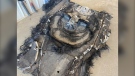
From outer space? Sask. farmers baffled after discovering strange wreckage in field
A family of fifth generation farmers from Ituna, Sask. are trying to find answers after discovering several strange objects lying on their land.
Why these immigrants to Canada say they're thinking about leaving, or have already moved on
For some immigrants, their dreams of permanently settling in Canada have taken an unexpected twist.
Ontario family receives massive hospital bill as part of LTC law, refuses to pay
A southwestern Ontario woman has received an $8,400 bill from a hospital in Windsor, Ont., after she refused to put her mother in a nursing home she hated -- and she says she has no intention of paying it.
Here are the ultraprocessed foods you most need to avoid, according to a 30-year study
Studies have shown that ultraprocessed foods can have a detrimental impact on health. But 30 years of research show they don’t all have the same impact.
Miss Teen USA steps down just days after Miss USA's resignation
Miss Teen USA resigned Wednesday, sending further shock waves through the pageant community just days after Miss USA said she would relinquish her crown.
Cyclist strikes child crossing the street to catch school bus in Montreal
A video circulating on social media of a young girl being hit by a bike has some calling for better safety and more caution when designing bike lanes in the city. The video shows a four-year-old girl crossing Jeanne-Mance Street in Montreal's Plateau neighbourhood to get on a school bus stopped on the opposite side of the street
BREAKING
BREAKING 6 injured in Sharbot Lake, Ont. crash; 2 in life-threatening condition
Ontario Provincial Police say six people have suffered severe injuries in a single-vehicle crash in Sharbot Lake, Ont, including two in life-threatening condition.
Shopping Trends
The Shopping Trends team is independent of the journalists at CTV News. We may earn a commission when you use our links to shop. Read about us.


Saskatoon
-

'Hours, not days': Concerns grow around accuracy of THC roadside testing in Sask.
Concern is growing around roadside THC testing, cannabis use and driving in Saskatchewan.
-
Sask. education minister says teachers' vote results could lengthen school year
Saskatchewan's education minister is being accused of trying to influence a teachers vote after saying he's not ruling out extending the school year should educators reject his offer and take job action.
-
From outer space? Sask. farmers baffled after discovering strange wreckage in field
A family of fifth generation farmers from Ituna, Sask. are trying to find answers after discovering several strange objects lying on their land.
Winnipeg
-

Winnipeg trial hears victims' clothing, jewelry found in serial killer's apartment
The trial of serial killer Jeremy Skibicki heard Thursday that police found physical evidence of the victims in his apartment, including jewelry, clothing, DNA and a blood-stained bathtub.
-
Last-ditch effort to keep St. Boniface pool open voted down by city committee
A last-ditch effort to keep a St. Boniface pool open for another year may have gone down the drain for good.
-
Winnipeg wants your opinion on the future of Graham Avenue
The City of Winnipeg is looking for public feedback on a new vision for Graham Avenue that will see it become a multi-use corridor focused on pedestrians and activities.
Edmonton
-

Zach Hyman gifts signed Oilers jersey to 'Shaq Hyman'
Edmonton Oilers forward Zach Hyman gifted a signed #18 jersey to NBA legend Shaquille O'Neal.
-
2024 pool season: Queen Elizabeth to open by long weekend, Mill Creek to open for first time in 4 years
Two of Edmonton's outdoor pools are scheduled to be open by the end of the month and the season will also see the reopening of the renovated Mill Creek Outdoor Pool.
-
Grande Prairie region under fire ban heading into expected dry, windy weekend
A fire ban has been reinstated in the Grande Prairie Forest Area, where the fire risk is highest in Alberta as temperatures climb.
Calgary
-

Calgary police release sketch of man found dead near Bow River
Calgary police have released the composite sketch of a man found dead near the Bow River in March in hopes it will assist the public in identifying him.
-
Calgary Transit sets new record for monthly riders, hitting 8.79M in March
Calgary Transit set a new one-month ridership record in March, when close to eight million boardings were recorded, the city said in a media release Thursday.
-
Firebirds outgun the Wranglers 7-5 in AHL playoff barn burner
A third period double-minor penalty proved to be the Calgary Wranglers’ undoing Wednesday night as they lost to the Coachella Valley Firebirds 7-5 in Game 3 of their best-of-five AHL playoff series.
Lethbridge
-
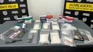
Four arrested in drug bust in Medicine Hat, Alta.
Four people are facing a series of charges following a drug bust in Medicine Hat last month.
-
Lethbridge police seek suspects after $4,000 in sunglasses stolen
Lethbridge police are looking for a pair of suspects they say took $4,000 worth of sunglasses from a local business.
-
Brooks Bandits getting ready for BCHL Alberta division finals
It took seven games, but the Brooks Bandits were able to knock off the Okotoks Oilers in the BCHL Alberta division semi-finals. After a hard-fought series, the Bandits are feeling battle-tested.
Toronto
-
BREAKING
BREAKING Another suspect arrested in Toronto Pearson airport gold heist: police
Another suspect is in custody in connection with the gold heist at Toronto Pearson International Airport last year, police say.
-
BREAKING
BREAKING Sheldon Keefe out as head coach of Toronto Maple Leafs
The Toronto Maple Leafs have fired head coach Sheldon Keefe. The team made the announcement Thursday after the Original Six franchise lost to the Boston Bruins in seven games in the first round of the Stanley Cup playoffs.
-
'Completely unworthy of belief': Toronto cop who stole credit cards, luxury watch from the dead found guilty
A veteran Toronto police officer was found guilty this week of stealing credit cards and a $6,500 watch from the deceased individuals he was tasked with investigating.
Ottawa
-
 BREAKING
BREAKING 6 injured in Sharbot Lake, Ont. crash; 2 in life-threatening condition
Ontario Provincial Police say six people have suffered severe injuries in a single-vehicle crash in Sharbot Lake, Ont, including two in life-threatening condition.
-
Ottawa police looking to identify suspect involved with assault in Chinatown
The Ottawa Police Service is asking the public for help in identifying a suspect involved with an assault that happened in Chinatown earlier this month.
-
This Ottawa ward has the most complaints about rats so far in 2024
Bylaw and Regulatory Services received 119 service requests for rats on private property so far in 2024, after receiving 779 service requests in 2023.
Montreal
-

Man pleads guilty in Montreal hit-and-run that killed 7-year-old Ukrainian refugee
A Quebec man has pleaded guilty to a fatal hit-and-run in Montreal that killed seven-year-old Mariia Legenkovska, a Ukrainian refugee who had just fled the Russian invasion in Ukraine.
-
Cyclist strikes child crossing the street to catch school bus in Montreal
A video circulating on social media of a young girl being hit by a bike has some calling for better safety and more caution when designing bike lanes in the city. The video shows a four-year-old girl crossing Jeanne-Mance Street in Montreal's Plateau neighbourhood to get on a school bus stopped on the opposite side of the street
-
Man accused of killing two children at Quebec daycare to stand trial in April 2025
The man accused of murdering two children and injuring six others after a city bus crashed into a Montreal-area daycare is scheduled to stand trial over five weeks beginning in April 2025.
Vancouver
-
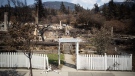
B.C. wildfires likely to spread with weekend temperatures expected to soar, province says
Wildfire and emergency management officials in British Columbia are urging residents to be prepared for increased fire activity as temperatures are expected to soar above 30 C in parts of the province this weekend.
-
Police searching for driver after cyclist seriously injured in hit-and-run crash near Victoria
Mounties on Vancouver Island are searching for the driver of a Jeep Wrangler after a cyclist suffered serious injuries in an alleged hit-and-run collision near Victoria early Thursday morning.
-
Rivers recede as B.C. faces prospect of 'unfamiliar territory' for drought
Parts of British Columbia will likely enter "unfamiliar territory" with drought if they see another hot, dry summer, says the head of the province's River Forecast Centre.
Vancouver Island
-

Police searching for driver after cyclist seriously injured in hit-and-run crash near Victoria
Mounties on Vancouver Island are searching for the driver of a Jeep Wrangler after a cyclist suffered serious injuries in an alleged hit-and-run collision near Victoria early Thursday morning.
-
B.C. wildfires likely to spread with weekend temperatures expected to soar, province says
Wildfire and emergency management officials in British Columbia are urging residents to be prepared for increased fire activity as temperatures are expected to soar above 30 C in parts of the province this weekend.
-
Galápagos Islands mail mystery solved after phone call from stranger
When Sherry Kirkvold played the voicemail message from a stranger – which began with, “Hi. This is kind of a random message for you. This one’s been a while.” – she couldn’t have been more surprised.
Kelowna
-

Kamloops RCMP issue public warning about 2 men allegedly at centre of 'organized crime conflict'
After four targeted shootings in four days, Mounties in Kamloops are taking the unusual step of warning the public about two men they believe are likely to be targeted in future violent incidents.
-
Community mourns thousands of fish lost as B.C. drought risk looms again
Images of steelhead and trout flicker over long sheets of paper, brought to life in blue and green crayon rubbings by the thousands.
-
4th targeted shooting in as many days in Kamloops: RCMP
A man was taken to hospital with non-life-threatening injuries after a shooting in Kamloops Monday evening, the fourth incident police say is part of an ongoing drug conflict playing out on the city's streets.
London
-

Josh Morgan announces separation from his wife
London Mayor Josh Morgan has announced the separation between him and his wife Melanie.
-
OPP searching for three masked suspects after stabbing in Norwich
One person suffered non life-threatening injuries following a stabbing Wednesday night in Norwich.
-
Wilfrid Laurier football player drafted despite only playing 27 games in his entire life
A Listowel, Ont. man, drafted by the Hamilton Tigercats last week, is also getting looks from the NFL, despite only playing 27 games of football in his life.
Kitchener
-

Wilfrid Laurier football player drafted despite only playing 27 games in his entire life
A Listowel, Ont. man, drafted by the Hamilton Tigercats last week, is also getting looks from the NFL, despite only playing 27 games of football in his life.
-
Long-time CKCO personality, Janine Grespan, dies at 63
A broadcaster familiar to many CTV News watchers has died at the age of 63.
-
BREAKING
BREAKING Another suspect arrested in Toronto Pearson airport gold heist: police
Another suspect is in custody in connection with the gold heist at Toronto Pearson International Airport last year, police say.
Northern Ontario
-

Skeletal remains found in Sudbury identified man missing since 2013
Sudbury police say they have identified the skeletal remains found last week in a wood area of Chelmsford and that no foul play was involved.
-
Here are the ultraprocessed foods you most need to avoid, according to a 30-year study
Studies have shown that ultraprocessed foods can have a detrimental impact on health. But 30 years of research show they don’t all have the same impact.
-
BREAKING
BREAKING Sheldon Keefe out as head coach of Toronto Maple Leafs
The Toronto Maple Leafs have fired head coach Sheldon Keefe. The team made the announcement Thursday after the Original Six franchise lost to the Boston Bruins in seven games in the first round of the Stanley Cup playoffs.
Atlantic
-

'Nobody should be getting away with murder': Grieving mother speaks out after son killed in North Preston, N.S.
A grieving mother is speaking out after her 36-year-old son was shot and killed in North Preston, N.S., Wednesday night.
-
Trucker's body found in trailer in Newfoundland after failed police search in Ontario
Ontario Provincial Police are facing tough questions about their search for a missing Newfoundland trucker whose rig was found two weeks ago in Ontario, then sent back to Newfoundland, where his body was found Monday in the trailer.
-
Impaired driver allegedly crashed into N.S. RCMP detachment
A Nova Scotia RCMP detachment was damaged after an impaired driver allegedly crashed into the building in Waycobah early Thursday morning.
N.L.
-

Trucker's body found in trailer in Newfoundland after failed police search in Ontario
Ontario Provincial Police are facing tough questions about their search for a missing Newfoundland trucker whose rig was found two weeks ago in Ontario, then sent back to Newfoundland, where his body was found Monday in the trailer.
-
Crown, defence present closing arguments for N.L. lawyer accused of sexual assault
The trial of a Newfoundland lawyer accused of sexual assault ended Tuesday with his defence team alleging the complainant lied under oath, while the prosecution said her memory lapses were understandable.
-
Newfoundland and Labrador latest province to tighten rules on Airbnbs
Newfoundland and Labrador is the latest jurisdiction to bring in stricter rules for short-term rentals, with a coming set of regulations that will force operators to register with the provincial government.


